Updated Maps and Course info for all distances coming soon!
Older Information:
The well-marked course will be run counter-clockwise around the perimeter of the park beginning near the main parking lot off of Bittersweet Rd. The half marathon course is two loops of the 10k course, with a detour on the 2nd loop (yet to be revealed). There will be one water-stop at the spillway, approximately 3.6 miles into the race. The start/finish area will serve as a 2nd aid station for the half marathon, resulting in runners experiencing no more than 4.5 miles without refreshments available. Please carry water if you think you may need to.
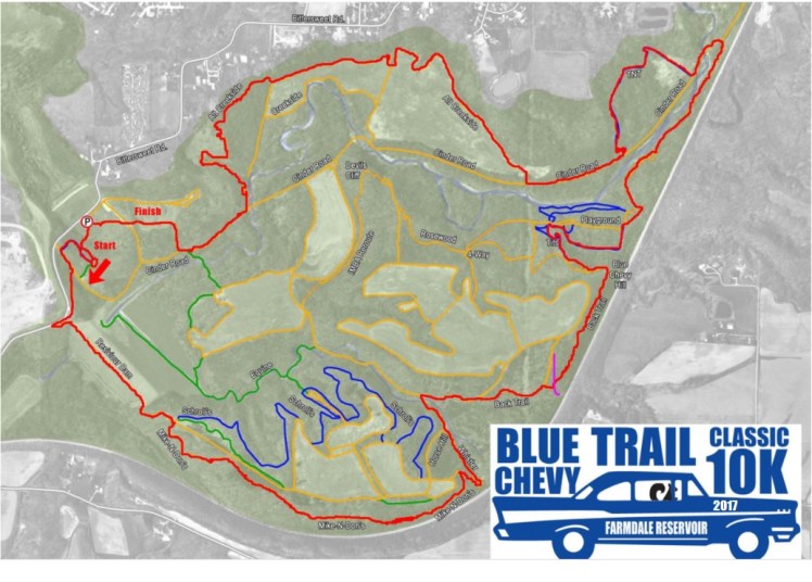
The route will use the following trails:
- Dam Trail from the parking lot over the dam
- Turn right onto Mike n’ Don’s
- Follow Mike n’ Don’s to the right turn downhill to Whistler
- Take the fire road from Whister to the right turn onto Back Trail
- At the end of Whister, countinue onto Blue Chevy
- Blue Chevy will become Knock Knock at the steep downhill
- From Knock Knock turn right onto Playground
- Follow Playground across the small creek and turn right toward the spillway
- An aid station will be available at the spillway (approximately mile 4)
- After the spillway, go uphill and turn right toward Track Stand
- Follow Track Stand to the fire road, turning right toward Alt Creekside
- At the end of Alt Creekside, turn right on the fire road toward the parking lot
